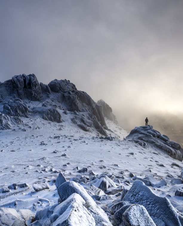
Climbing Slieve Binnian from Carrick Little (for novice hikers)
Family-Friendly Mourne Mountains
Would you like to sponsor this article?

Aughrim Hill (251m) and Knockchree, also known as Knockcree (306m), fall into the small category in any discussion of hillwalking. However, both have their charms not least of which are the fabulous views that surround them. Their neighbouring locations, tucked in between the Irish Sea, Carlingford Lough and the higher Mourne peaks, guarantee expansive panoramic vistas of mountain, sea and countryside.
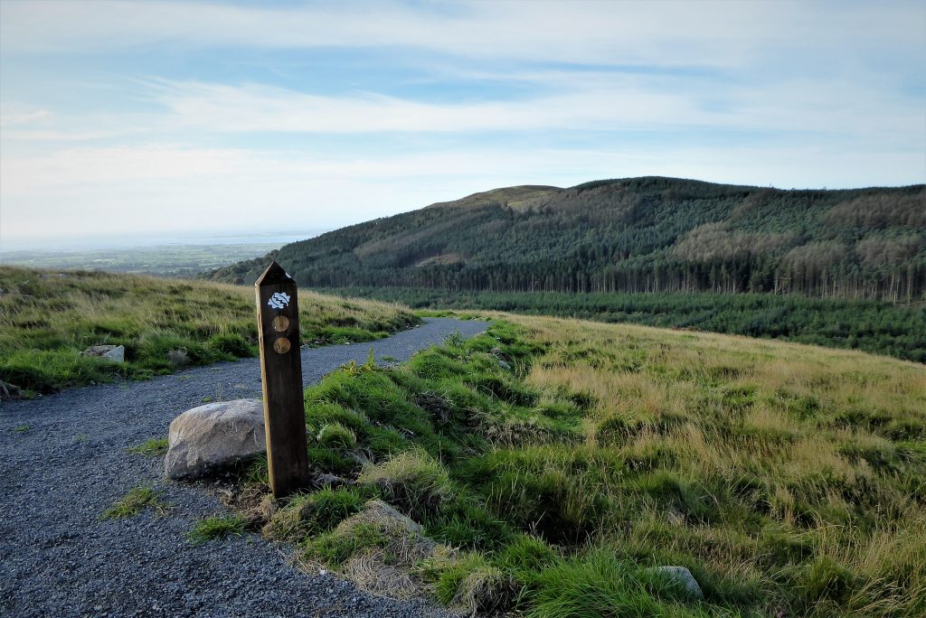
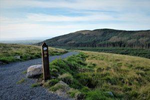
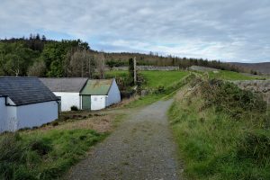
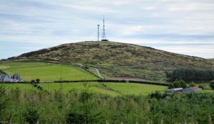
Aughrim Hill has recently been the beneficiary of one of the biggest and most ambitious tree planting projects in County Down. A total of 110,000 native trees have been planted by hand to create a woodland habitat stretching over one hundred acres of hillside. In tandem with the tree planting, a network of paths has been created to enable public access. A small, but well-appointed car park makes for convenient and safe access. The Daera-funded project represents a partnership between the Forestry Service, the Woodland Trust and Mourne Heritage Trust.

SHOP: Get FREE DELIVERY when you spend £50 in store now!
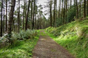
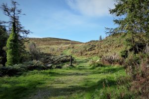
Find Out MoreStarting at the car park, you have a choice of paths of varying gradients. Facing the transmitter masts, the path to the left is the steepest, but the surface is excellent as it incorporates the transmitter service road. The path to the right of the car park presents a slightly more gentle option. Several offshoots at various points give access to the transmitters. The steepness of these paths is mitigated by their zigzag pattern. Another entrance, accessed by a gate further down Ballymageogh Road, offers a gentle ascent through newly planted trees.
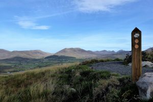
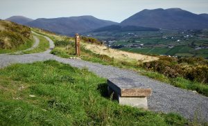
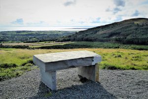
The sturdy waymarker posts, emblazoned with the Woodland Trust logo, have space for direction arrows which hopefully will be added later. Several stone seats are strategically placed at various viewpoints.
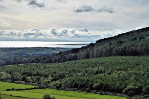
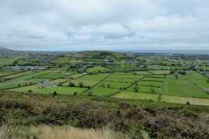
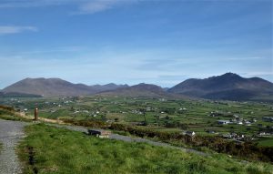
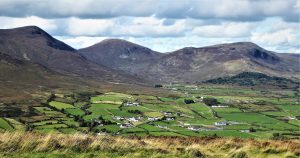
It is possible to make a complete circuit of the hill on one path, with the option of using any of the offshoots to explore the middle section. Taking an anti-clockwise course, the views will begin by encompassing heavily forested neighbour Knockchree, followed by a gradually expanding vista that includes Carlingford Lough and the Irish Sea.
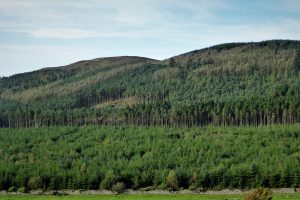
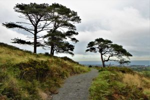
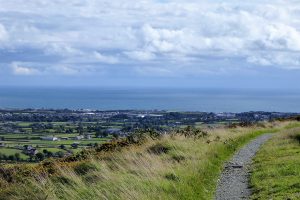
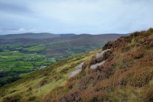
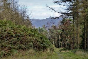
As the path approaches the eastern tip of the hill, a group of mature Scots Pine interrupt the largely treeless landscape. The young tree plantings are just about visible on the lower slopes but it will take time before they make a significant impact on the environment. Rounding the most easterly part of the path, the fertile County Down fieldscape stretches like a green patchwork quilt towards the coast.
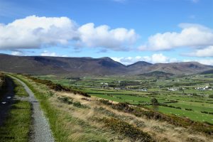
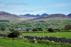
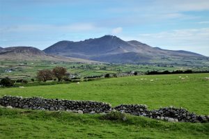
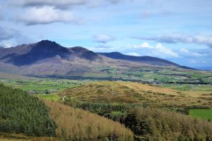
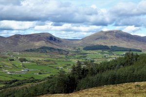
The coast is left behind as the path begins its journey north to face the main body of the Mournes. The views are sublime with at least twenty peaks populating the horizon. Binnian and its rugged tors hog the limelight as the path proceeds north, perspectives varying as the angle of sight changes.
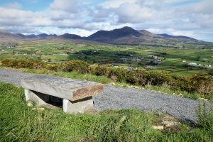
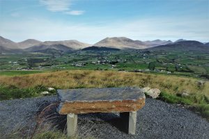
A diversion to the summit transmitters reaches the highest point of the hill with views to match its elevated position. Stone benches sit to the north and south providing comfortable vantage points to enjoy the sumptuous scenery.
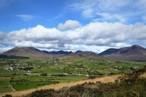
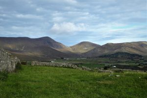
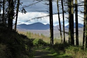
Returning to the main path, still travelling anti-clockwise, the path drifts north-west, with the Shanlieve ridge and Eagle Mountain making their appearance. The saddle between Eagle and Slievemoughanmore is clearly visible with Pigeon Rock Mountain and Slieve Muck further to the east. The path soon curls to the west and back down to the car park.
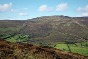
To reach Knockchree, turn right from the car park and walk about 200m up Ballymageogh Road and turn left at a farm track. Pass a farm gate and a white holiday cottage and squeeze past a forestry gate to arrive at the path that leads to the summit. The views to the north continue to entrance, dry-stone walls adding their artisanal charms to the mountain landscape.
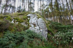
Keep on the path as it veers left, ignoring the track that leads off to the right. A look over at Aughrim Hill gives a lofty view of the path layout. A few metres up the track, a large rocky outcrop adds some variety to the forestry, which is mainly conifers interspersed with holly, sycamore, rowan and oak. The track becomes progressively steep, but remains manageable, until it levels out as it approaches a gate that leads to the treeless summit. The final few metres to the top are quite steep, but the grassy surface enables comfortable walking with good traction.
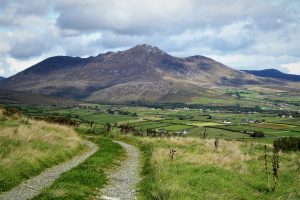
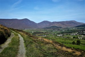
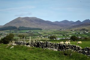
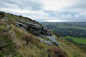
The eastern edge of the summit area has a few small rocky crags, but the ground cover is mainly grass with some heather and gorse. The summit itself seems to be marked by what can only be described as a mangled piece of iron, but it fails to detract from the views which are as extensive as they are spectacular. To the north-east, Binnian sweeps down towards the coast, while a little to its left the symmetrical form of Doan gives way to Meelmore, Meelbeg and Bearnagh. Further left, Slieve Muck and Pigeon Rock Mountain face one another, separated by the col that hosts Moyad Road.
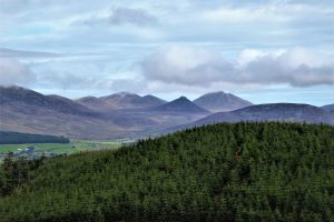
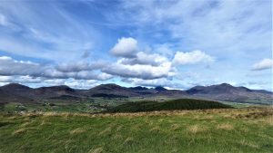
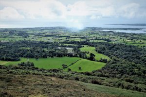
The northern aspect sees Pigeon Rock Mountain joined by Slievemoughanmore and Eagle Mountain. Finlieve sits a little further to the north-west and the elevated view clearly picks out the old bog road that leads down the mountain to Glenloughan Road.
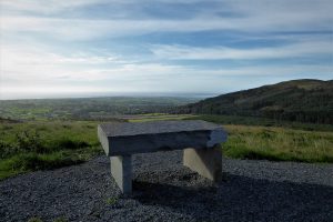
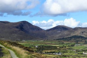
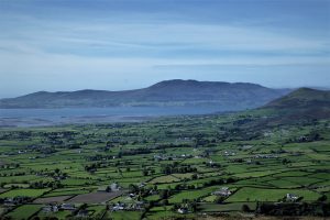
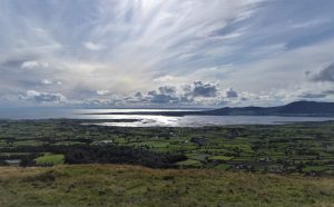
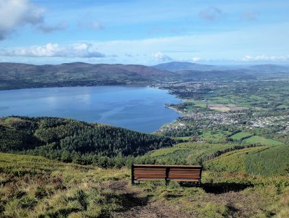
The hills north of Rostrevor populate the view to the south with Slievemeen and Slievemartin prominent. Carlingford Lough and the Cooley Mountains sit a little further to the south-east. Immediately south of the summit, the green countryside accommodates the more manicured landscape of Kilkeel Golf Club and, close by, Mourne Park. The Woodland Trust has recently taken ownership and management of 386 acres of the Mourne Park estate with a view to restoring ancient woodland. The charity plans to open the woodland to the public in 2022.
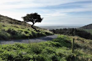
The return walk is virtually all downhill with gaps in the trees offering tantalising glimpses of the mountains beyond.
READ: Slievemeen, Slievemartin and Crenville: A Southern Mournes Trio
Find Out MoreOctober 2021
If approaching from the north, head for Spelga Dam and continue on the B27 for about 6 miles until you reach a right turn for Attical. Go straight through Attical onto Tullyframe Road for about half a mile before turning left onto Ballymageogh Road. The road runs uphill at first beside Aughrim Hill. As it begins to head down look out for the small car park on the left.
4.5km (3 miles) for Knockchree; choose how far you wish to walk on Aughrim Hill, but the complete circuit without diversions is about 2.5km
About 1½ hours for Knockchree, around an hour for Aughrim Hill.
…you enjoy a walk with spectacular views, without being too bothered about the number of miles or the size of challenge presented. Aughrim Hill would be suitable for all the family as would Knockchree, although it would require a moderate level of fitness and sturdy footwear. Very little of the walking should present a challenge and the few steeper sections are quite short-lived. Dogs on lead are welcome on both walks.
There is a fairly well tramped path leading from the summit of Knockchree to the west. Time constraints prevented me from investigating it apart from following it down through heather and gorse for about 70m. It seems to end up in dense forestry, but the path raises the prospect of an alternative ascent/descent of the hill and the possibility of a looped walk. More information to follow…

Derek, 76, spent 35 years working in national, academic and public libraries, followed by 14 years in the wine trade. He only began serious walking in his 60s, although he had previously travelled many miles on foot pursuing his favourite hobby of fishing. After retirement, he decided to give the fish a rest and bother the hills of Ireland and Britain instead. Derek regards walking as a simple pleasure to be enjoyed, not endured, and prefers a solo hike in quiet, remote surroundings.

Climbing Slieve Binnian from Carrick Little (for novice hikers)
Denvir’s of Downpatrick: The Perfect Base for Walkers and Explorers in County Down
5 Outstanding Late Winter Hikes in the Mourne Mountains
Willowtree Glamping: a Romantic, Rural Retreat in the Mournes
 Belfast,Photography
5 scenic walks around Lisburn
 Mourne Mountains
Bearnagh: Chased the sunset, caught the rain
 Mourne Mountains
Camping in the High Mournes
 Fermanagh and Tyrone
Cuilcagh: Stairway to Heaven
 Features
Every Game of Thrones Location in Northern Ireland
 Mourne Mountains
Hen and Cock Mountains
 Mourne Mountains
Leganabrachan, Millstone and Thomas: Donard’s Seaside Bodyguards
 Mourne Mountains
Percy Bysshe and Cove Caves
