
Climbing Slieve Binnian from Carrick Little (for novice hikers)
Would you like to sponsor this article?

NI has many beautiful spots such as Divis, Clandeboye Estate and Bangor along the coast in either direction to name a few in my area. However, the Mournes are unique in the fact that they’re a mountain range, are very challenging, and feature an elevation factor unrivalled in NI. Having been in many locations in the range with different races on the mountain running calendar I was seduced by The Annalong Horseshoe.
READ: Snapshot Trek: Hare’s Castle
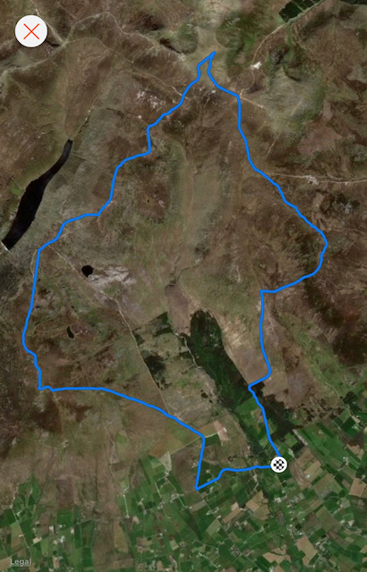
Distance : 13.1 miles or 21.1km
Climbing : 1371m
Start : Dunneywater, Head Road, Annalong
Mourne OS Grid : J358223
Mountains covered:
Chimney Rock 364257
Commedagh 346286
Cove 336270
Slievelamagan 329260
Binnian 320234
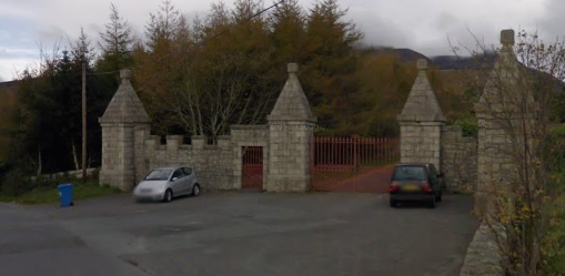
Via Newcastle, take the coastal road towards Annalong and Kilkeel. About six miles out of Newcastle, and 3/4 mile before you come to Annalong, turn right on to Quarter Road, immediately past the petrol station on right hand side of the road. It’s signed Silent Valley 5 miles. At the top of Quarter road turn sharp left on to the Head Road and park at large gated entrance which is on your right, just 300 metres along the road.
READ: Gemma O’Neill’s Causeway Coast
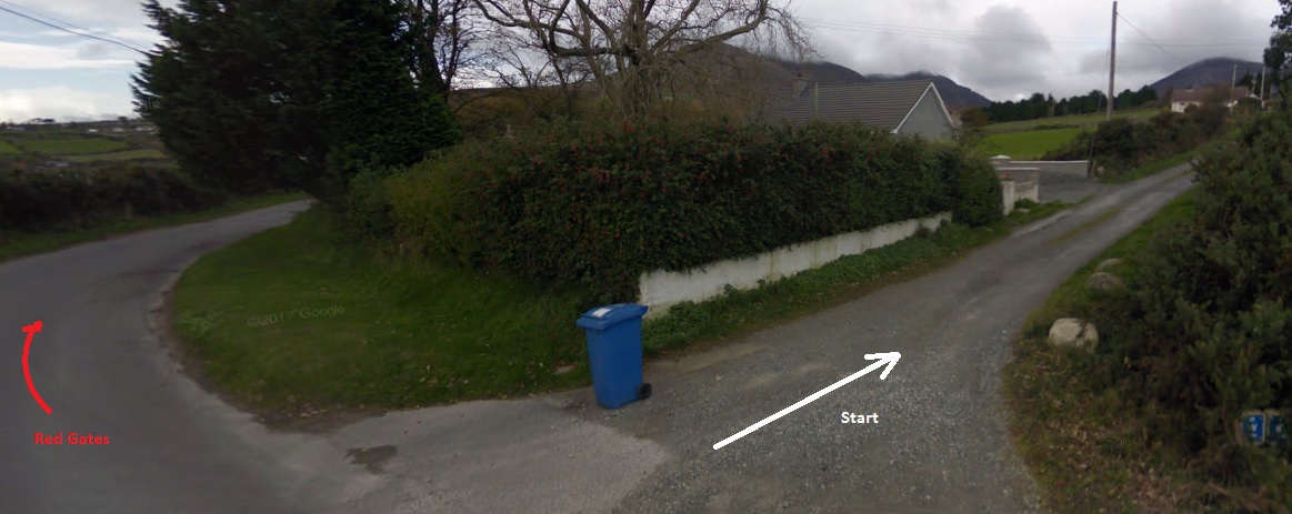
With your back to the gates, go left down the road (east) about 30 metres then up this lane. It is rocky, uneven and climbs steadily but straight all the way until a farmers gate. There is a small wall on the right with a stile – go over it.
At this point you can go straight keeping the wall on your right until you hit the Mourne wall. About 60/70m up there will be a small track (with a constant trickle of water) on the left that will climb more acutely to the wall in a diagonal.
From either direction when you hit the wall continue on to a stile that is located between Rocky and Long Seefin. Over the stile you can see a small track in the heather that leads across to Chimney Rock, on both days it was laden in mist but another track can be found on the south side that will take you to the summit.
Coming off the summit isn’t difficult but in the mist getting the right bearing is a must in order to hit the stile that will bring you on to the Brandy Pad underneath Slieve Donard. On a clear day the stile will be visible from afar, the ground towards it is bog and can sap the energy though so take it steady.
Follow the Brandy Pad that will lead you up to the saddle, cross the stile and keep the Mourne Wall on your left, ascending to the Commedagh Tower. That’s two of your five climbs complete but get this descent wrong and you could take in an extra climb.
Going over the stile at the tower simply head straight down (very steep) again towards the Brandy Pad and Slieve Beg. The trick is not to climb Slieve Beg, simply to roll over its shoulder on the left, hit the path and climb Cove. The terrain again is heather.
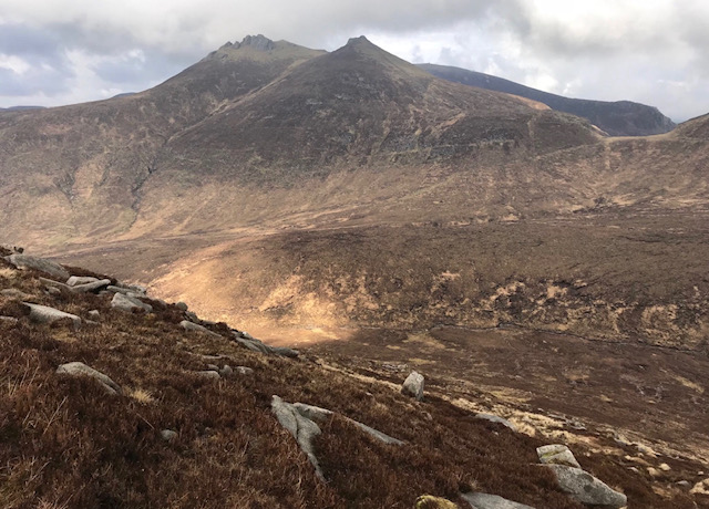
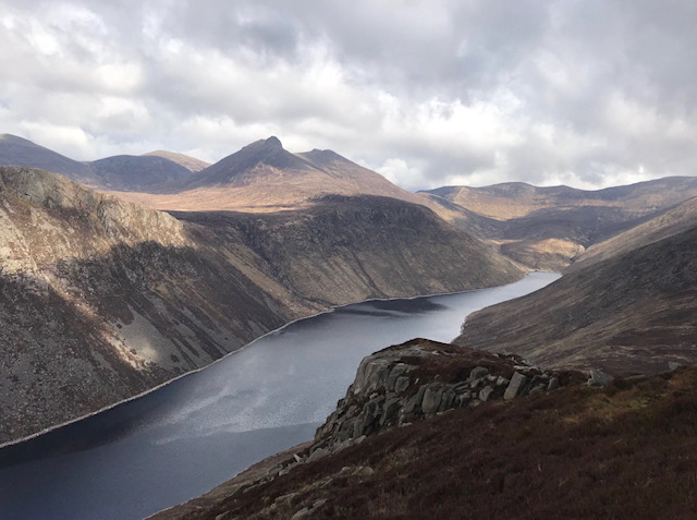
At this point I would advise on a clear day to stop and admire with a 360, get something to eat and simply take it all in. My pic below is looking towards Hares Gap with Bearnagh (my favourite mountain) in all its glory.

The descent off Cove is bumpy underfoot but quick, and leads you straight on to Lamagan. By this point pause to take in the view and eat something – although it’s a short climb, you will have been out for a few hours now.
On my rec to the top of Lamagan I followed the path over the summit for a short period but that was a mistake. I veered right and descended – it’s rough, rock-laden and tough on the quads, but I was too far down the valley and had to hit the path and walk back up.
When you hit Lamagan summit, do a 90-degree turn right and head straight down. This will lead you to a rock-filled but good path to the base of Binnian. Stamina will be starting to lag now. Binnian starts with rocky steps and a scrambleclimb up on to the main track, which is well-used, and there should be many a walker on it no matter the time of day. At this point the views are simply outstanding, so again stop and appreciate everything around you.
Follow the well-worn path all the way to the summit.
For the descent you need to pick up the Mourne Wall and a descent between the tors should get you there. Again, on my race I missed the wall and had to aim straight for the valley path and go down through very heavy grass and a watered field which isn’t good at the end of such a long trek.
Keep the wall on your right all the way to the track, nearly there now. Downhill all the way on a good track to Carrick Little and then a left back along the road for about a mile. Ensure you walk towards the traffic – use the verge when you can and keep safe as it’s a narrow road with tight bends. Unfortunately the last 70 metres is all uphill to those red gates but after the day you have had, you will not care.
Pre-race I recced the route to ensure I had my bearings even if the weather turned bad and the mist rolled in. I went down at 7am more to get parked up, get it done and get home to the family than a conscious decision at a certain time. There is something however about going early, out there, just you and the mountains though.
Race day kicked off at 11am.
As it was the same time of year on both days the weather was close to identical. Water underfoot in most parts, misty to start and then a clearing to blue sky and a return to the mist on the way home. Temperature was not an issue, no humidity and not cold.
It was May, post winter and pre-summer. The best time to tackle this after the cold and the brutality of winter has passed but well before the effects of summer in the mountains, mainly dehydration can kick in. Carrying anything extra especially water can make any hikerun a different prospect and especially if the sun is beating down difficulties can occur.
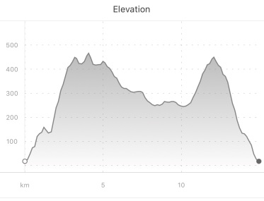
This is a routehike that would need to be worked up to. It isn’t for the casual walker – it’s for the experienced hiker. Underfoot there is very little track, mostly rough sodden ground and on a bad weather day, location, map reading and knowing your bearings are all required to ensure a finish and especially for safety. It took nearly 3 hours to run on race day but it isn’t all running and so 6 with breaks should be about right, so prepare for a long day.
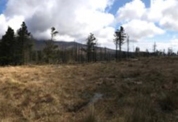
I really liked the fact that it didn’t start from the usual Donard Park area but tackled the mountains from the other direction down the coast on the Head Road. It is tough in the fact there is a lot of boggy ground and heather and after the first climb they just keeping coming with the ascent to Binnian – a real stamina sapper but all worthwhile.
It’s the views though, just a few iPhone shots show you what sights you are in for if the day is clear.
It is long, has loads of elevation and bad ground, so be prepared. Mandatory waterproof coat and trousers (with taped seams), map and compass (know how to use them), whistle, foil blanket, water and food (as much as you can carry). Even when running these are easily carried so no excuse with a day sack or rucksack on a hike.
I always have a charged phone and leave a map of my route at home with family and on the dash of my car with the time of departure, expected duration and arrival back time.
I also message family on departure of my hike.
You can follow Mark on Twitter.
NDAC athlete since 1982. Track, XC and road runner that took to mountain running in 2017. Starting out on Hill n Dale and progressing to the NIMRA series races.
 Belfast,Photography
5 scenic walks around Lisburn
 Mourne Mountains
Bearnagh: Chased the sunset, caught the rain
 Mourne Mountains
Camping in the High Mournes
 Fermanagh and Tyrone
Cuilcagh: Stairway to Heaven
 Features
Every Game of Thrones Location in Northern Ireland
 Mourne Mountains
Hen and Cock Mountains
 Mourne Mountains
Leganabrachan, Millstone and Thomas: Donard’s Seaside Bodyguards
 Mourne Mountains
Percy Bysshe and Cove Caves
